
Home
Lost Reg Code?
News
Online KiwiSDRs
macOS Software
Windows Software
Ham Radio iPhone/iPad
Linux Software
Support/FAQ
Update Policy
USB Icom CI-V Interface
Radio Hobbyist Products
22m Programmable Beacon Kit
CW Keyer For Beacons Kit
Jellyfish Transformer
Cyclops Antenna Transformer
General Interest Programs
Atomic Mac/PC
Audiocorder
Audio Toolbox
Black Cat Timer
Diet Sleuth
iUnit
Graffikon
Graph Paper Maker
Health Tracker
Image Resizer
Knitting Wizard
Label Wizard
Prog Audio Gen
Sound Byte
Synth 76477
Amateur Radio Programs
AirSpyHF+ Server
Audiocorder
Black Cat Absolute ACARS
Black Cat ACARS
Black Cat ALE
Black Cat ALE Vacuum Cleaner
Black Cat NetFinder
Black Cat GMDSS
Black Cat HF Fax
Black Cat SSTV
Black Cat NAVTEX SITOR-B
Carrier Sleuth
Cocoa 1090
Cocoa RTL Server
DGPS Decoding
DX Toolbox
Elmer
MatchMaker
KiwiKonnect
KiwiSDR Monitor
KiwiSDR Sound Client
MININEC Pro
Morse Mania
MultiMode
sdrRewind
RF Toolbox
SDRuno Plugin
SDRuno Equalizer Plugin
SelCall
Sonde
iPhone/iPad Apps
ALE
Atoms To Go
dB Calc
Clik Trak
DGPS Decoder
Drill Calc
DX Toolbox
Elmer Extra
Elmer General
Elmer Tech
Feld Hellschreiber
Field Strength Calc
Function Generator Pad
GMDSS
Godafoss
HF Weather Fax
iAttenuate
iFunctionGenerator
iSoundex
iSoundByte
iSweep
iUnit
Morse Mania
ACARS Pad
Morse Pad
NAVTEX Pad
Packet Pad
PSK31 Pad
SSTV Pad
Photon Calc
Rad Map Tracker
RF Link Calc
SelCall Tone Gen
Sound Byte
Sound Byte Control
Spectrum Pad
SWBC Schedules
Synth 76477
Synth Motion
Transmission Line Calc
Weather Calc
Wire Calc
iPhone/iPad Bundles
RF Calculator Apps
Ham Radio Decoder Apps
Audio Utility Apps
Shortwave Weather Apps
Ham Radio Exam Study Apps
Shortwave Decoder Apps
About Black Cat Systems
Site Map
Our software for Mac OSX
Privacy Policy
Press/Media
HFunderground
Apple /// Emulator
Macintosh Links
Shortwave Radio
Pirate Radio
Spy Numbers Stations
Science and Electronics
Ham Radio Software

Receiving Weather Fax and Weather Satellite Images With Your Macintosh
Introduction
How Weather Fax is transmitted over HF radio
How to receive weather fax images
How to receive weather satellite images
HF Weather Fax Schedules
Introduction
It's possible (and quite easy) to receive weather charts and satellite images, using nothing more than your computer and the appropriate radio. This short tutorial shows you how to do this using your Macintosh computer.I also have apps for the iPhone and iPad as well as Android
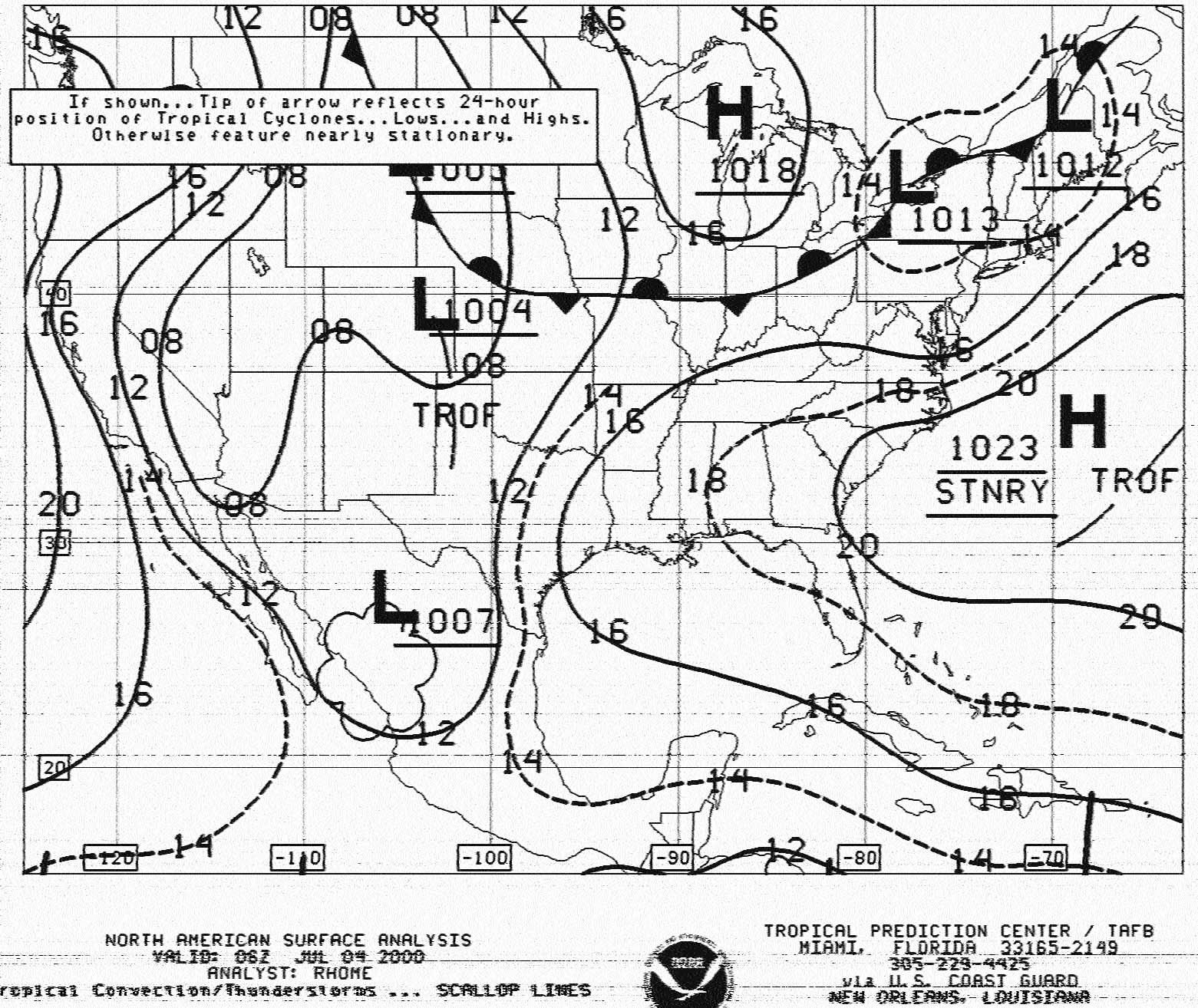 Surface Analysis Chart from NOAA/NHC
This first image is a Surface Analysis Chart. It was transmitted from the NOAA/NHC from the USGC
in New Orleans, Louisiana. Five USGC stations transmit weather fax at various times throughout the day.
Take a look at the HF Weather Fax Schedules further down in this document for
time and frequency information.
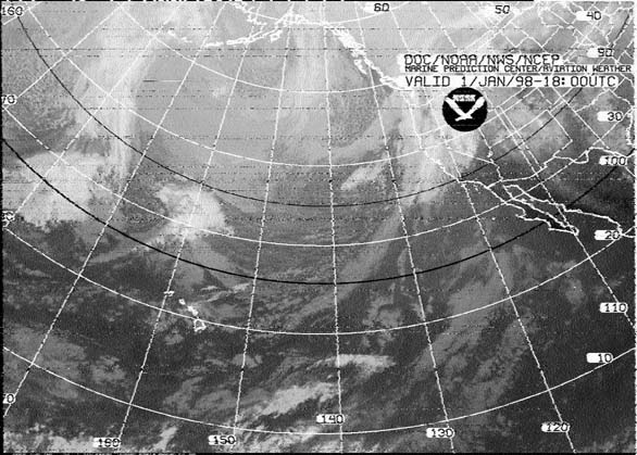 Weather satellite image re-transmitted over HF
This is a weather satellite image that was re-transmitted over shortwave radio. It's much easier to receive
these re-transmissions than it is to directly receive the image from the satellite.
How Weather Fax is transmitted over HF radio
A fax is transmitted line by line, typically at a rate of 120 lines per minute, or half a second per line. For example, to send a weather chart, you would start in the upper left corner. You would send the value of that pixel (dot), black, white, or perhaps a shade of gray. Then you would move over one pixel to the right, and send that pixel, and so on, until you reach the edge of the chart. Then you'd move all the way back to the left edge, and move down slightly, one line, and repeat the process.Each pixel is converted into a certain audio frequency or tone. By convention, a tone of 1500 Hz represents black, 2300 Hz represents white, and frequencies in-between represent shades of gray. So if you listen to a fax transmission, you'll hear the different tones as each pixel is present. For example, listen to a chart with mostly white background being sent. You'll hear mostl the high pitch 2300 Hz, and some lower (1500 Hz) blips as each black pixel is sent. When a horizontal line is sent, you'll hear a long half second burst of 1500 Hz, since the line is all black.
(A note for the purists: OK, The above was a simplification. In reality, the transmitting station frequency modulates the carrier. That is, when a black pixel is transmitted, the carrier shifts down 400 Hz. When a white pixel is transmitted, the carrier shifts up 400 Hz. For a medium gray pixel, it stays on the assigned frequency. This is how most fax transmissions are actually made. But, since we're tuning it in with a SSB receiver, it sounds to us as if the station is transmitting a variable frequency audio tone. Actually, the two processes are identical. But, this accounts for the confusion regarding what frequency to tune the radio to in order to properly decode the fax transmission. Different stations list their frequency in different ways. It is important to remember that what's really important is tuning the radio so that a black pixel produces a 1500 Hz tone, and a white pixel produces a 2300 Hz tone. )
How to receive weather fax images
In order to receive and decode fax images, you'll need an appropriate radio and antenna, and a cable to connect the audio output of the radio into your Macintosh computer's microphone jack. You'll also need appropriate software to display the images - such as MultiMode. MultiMode decodes weather fax and satellite images on your Macintosh, without the need for extra hardware.The only requirements of the radio are that it tunes the frequency ranges of interest. A general purpose communications receiver tuning 0-30 MHz is ideal, SSB marine radios may also be used, if they can receive the frequency bands of interest. The radio must be able to tune in USB (upper sideband) mode. Inexpensive portable radios are not as satisfactory, although higher-end units can work well. The radio must be able to tune in small steps (10 Hz), or have some sort of a fine tune adjustment.
A good antenna is a must. It should be located away from the computer, to minimize any pickup of radio interference. Good quality coax cable should be used to connect the antenna to the radio. Proper grounding will also help reduce interference and improve reception. An outside antenna (dipole or active antenna) is recommended.
Connecting the radio to the computer can be as easy as getting an audio cable (from say Radio Shack) with the proper connectors on each end. Often you can just plug a cable from the speaker or headphone jack of the radio directly into the Mac's microphone jack (which uses a 3.5 mm plug). You need to carefully adjust the volume on the radio to not over-drive the Mac's sound input, you don't want to blow anything up.
In a pinch, you can use a Mac microphone, and set it on top of the radio's speaker. You'll need to watch for outside sounds that can get picked up, and create interference.
Tuning in fax stations on HF (Shortwave radio)
There is a great deal of confusion on how to tune in fax stations. This is partly caused by the non-standard ways that stations state which frequency they transmit on. Some give the carrier frequency. Some give the center frequency. All we care about is making sure that when the fax station sends a black pixel, we hear a 1500 Hz tone, and when it sends a white pixel, we hear 2300 Hz. That's it. When you keep that in mind, tuning in a fax station is extremely simple.First, make sure MultiMode is set up correctly. You'll want to be in fax mode of course. Set the speed to 120 LPM (unless you know otherwise), and the mode to GREY and HF.
Next, tune in the station. You don't need to be precise yet, just make sure you can hear the fax audio. Make sure you've really tuned into the correct station, not a nearby station that may be sending RTTY or some other mode. Make sure you're not getting interference from other stations, and that the signal is fairly strong and clear. If it is noisy, your fax picture will be noisy as well.
When properly tuned in, the station should sound like this
Now, make sure the volume is appropriate. You want the volume indicator in MultiMode (the green bar in the upper right corner) to be around half-way, maybe more.
Finally you need to properly tune in the station. There is a small frequency graph display in the upper middle part of the MultiMode window. It shows what audio frequencies are present, typically this looks like a small bump or hill. There are two small ticks on the bottom of this, to indicate 1500 and 2300 Hz. You want to tune the radio until the bump is between the two ticks. Usually it is the same width, if the fax image being sent has shades all the way from black to white. If not, it may be slightly more narrow.
If you're decoding something, but it doesn't "look right", it's possible the station is using a mode other than 120 LPM.
At this point, you should be receiving something that looks like a proper image. Now fine tune the radio, in case some areas of white background look gray, or black lines look gray. If the audio tones are too high, the image will look too light. Likewise, if the audio tones are too low, the image will look dark. With practice, tuning will become natural. If your radio has digital readout with enough digits, you can note the frequency, so the next time you tune in the station, it is much easier. Just tune back to the same frequency, and you'll be all set.
If you're decoding a chart or other image that is only black and white, you can set MultiMode to LINE mode. In this setting, received pixels are converted to either pure black or white, with no gray. This sometimes produces better images.
If the picture looks correct, but is slanted, then the timing is probably slightly off. All computers run at slightly different speeds, this can cause this problem. It's easy to fix, just adjust the timing delta in MultiMode. This is typically a small number, 0 if everything is perfect, otherwise ranging from maybe -10 to 10. Decimals are allowed, such as -5.7 or similar.
Station Schedules
There is an excellent list of world wide fax schedules here: WORLDWIDE MARINE RADIOFACSIMILE BROADCAST SCHEDULESThere is a new book about receiving FAX transmissions called Just The Fax-Shortwave Weather Fax Reception
Here are transmission schedules for some of the major Weather Fax stations on HF radio:
GFA, Bracknell, UK
CFH, Halifax, Nova Scotia, Canada
NMC, US Coast Guard, Pt Reyes, California, USA
NMF, US Coast Guard, Boston, Massachusetts, USA
NMG, US Coast Guard, New Orleans, Louisiana, USA
KVM70, Honolulu, Hawaii, USA
GFA, Bracknell, UK
Frequencies:
- 2618.5 kHz: 1800-0600 UTC (tune radio to 2616.6 kHz)
- 4610.0 kHz: 0000-2400 UTC (tune radio to 4608.1 kHz)
- 8040.0 kHz: 0000-2400 UTC (tune radio to 8038.1 kHz)
- 14436.0 kHz: 0000-2400 UTC (tune radio to 14434.1 kHz)
- 18261.0 kHz: 0000-1800 UTC (tune radio to 18259.1 kHz)
WHITE + 400 HZ, BLACK - 400 HZ
Mode: 120 RPM
Schedule:
-----------------------------------------------------------
TIME   Chart                                  Valid   I.O.C.
------------------------------------------------------------
03:41  MSLP ANALYSIS FOR 00:00                00:00    288
04:31  500 HPA CONTOUR/TT (1000/500HPA)
       ANALYSIS FOR 00:00                     00:00    288
04:40  MSLP 24-HOUR FORECAST (VT 00:00)       00:00    288
08:06  MSLP 48-HOUR FORECAST (DT 00:00)       00:00    288
08:12  MSLP 72-HOUR FORECAST (DT 00:00)       00:00    576
08:18  NORTHERN HEMISPHERE SURFACE ANALYSIS   00:00    288
09:29  SEA/SWELL ANALYSIS FOR 00:00           00:00    288
09:35  SEA/SWELL 24-HOUR FORECAST             00:00    288
09:41  MSLP ANALYSIS FOR  06:00               06:00    288
10:00  500 HPA CONTOUR/TT (1000/500HPA)
       T+24 FORECAST                          00:00    288
10:10  SEA/SWELL 48-HOUR FORECAST             00:00    288
10:31  NORTH ATLANTIC INFERENCE               00:00    576
10:42  MSLP 24-HOUR FORECAST (VT 06:00)       06:00    288
14:12  UK SEA TEMPERATURE ANALYSIS            00:00    288
15:41  MSLP ANALYSIS FOR  12:00               12:00    288
16:02  NORTH ATLANTIC SEA ICE CHART           00:00    576
16:22  SCHEDULE: MARINE PRODUCTS              05:00    576
16:30  GENERAL NOTICES (if any)                        576
16:41  MSLP 24-HOUR FORECAST T+24 (VT 12:00)  12:00    288
17:08  500 HPA CONTOUR/TT (1000/500HPA)
       ANALYSIS FOR 12:00                     12:00    288
20:12  SEA/SWELL  ANALYSIS FOR 12:00          12:00    288
20:18  SEA/SWELL 24-HOUR FORECAST             12:00    288
21:41  MSLP ANALYSIS FOR  18:00               18:00    288
21:52  SEA/SWELL 48-HOUR FORECAST             12:00    288
22:22  MSLP 48-HOUR FORECAST (DT 12:00)       12:00    288
22:30  MSLP 72-HOUR FORECAST (DT 12:00)       12:00    288
22:41  MSLP 24-HOUR FORECAST (VT 18:00)       18:00    288
23:33  MSLP 96-HOUR FORECAST (DT 12:00)       12:00    288
23:40  MSLP 120-HOUR FORECAST(DT 12:00)       12:00    288
------------------------------------------------------------
CFH, Halifax, Nova Scotia, Canada
Frequencies:
- 122.5 kHz: 0000-2400 UTC (tune radio to 120.6 kHz)
- 4271.0 kHz: 0000-2400 UTC (tune radio to 4269.1 kHz)
- 6496.4 kHz: 0000-2400 UTC (tune radio to 6494.5 kHz)
- 10536.0 kHz: 0000-2400 UTC (tune radio to 10534.1 kHz)
- 13510.0 kHz: 0000-2400 UTC (tune radio to 13508.1 kHz)
Mode: 120 RPM, IOC: 576
Schedule:
-----------------------------------------------------------
Time UTC       Product
-----------------------------------------------------------
0001-0023      ice chart Labrador (if available) *1
0100-0118      Infrared satellite picture (18)
0201-0219      sig wx depiction VT1200
0301-0320      Infrared satellite picture (00)
0321-0339      surface analysis 0000
0401-0426      500 hPa analysis 0000
0501-0519      isobaric prog VT0000 (H+24)
0520-0537      850 hPa forecast wind/temp/height VT1800/0000
0601-0619      sig wx depiction VT1800
0620-0638      surface analysis 0000
0703-0721      sig wave prog VT1200 (H+12)
0722-0740      sig wave prog VT0000 (H+24)
0741-0759      isobaric prog VT1200 (H+36)
0801-0819      sig wave prog VT1200 (H+36)
0820-0838      sea surface temp (New Founland Wed, Sat) (Nova Scotia Sun, Thu)
               ocean feature anal (New Foundland Mon,Fri) (Nova Scotia Tue)
0901-0920      surface analysis 0600
1001-1024      Infrared satellite picture (06)
1101-1123      Shedule / Test chart
1201-1223      3 day surface prognosis (12)
1223-1241      4 day surface prognosis (12)
1245-1307      5 day surface prognosis (12)
1310-1318      Infrared satellite picture (12)
1401-1419      sig wx depiction VT0000
1501-1521      500 hPa analysis 1200
1522-1540      surface analysis 1200
1601-1624      850 hPa analysis 1200
1701-1719      isobaric prognosis VT1200 (H+24)
1801-1819      sig wx depiction VT0600
1820-1838      850 hPa forecast wind/temp/height VT 0600/1200
1901-1919      isobaric prognosis VT0000 (H+36)
1920-1938      sig wave prognosis VT0000 (H+12)
1939-1958      sig wave prognosis VT1200 (H+24)
2001-2018      sig wave prognosis VT0000 (H+36)
2019-2038      sea surface temp (New Foundland Mon, Wed, Sat)
               (Nova Scotia Tue, Thu, Fri, Sun)
2101-2122      Ocean feature analysis Newfoundland (Mon, Wed, Sat)
2123-2146      surface analysis 1800
2201-2232      ice chart New Foundland (if available) *1
2301-2323      ice chart Gulf of Saint Lawrence (if available) *1
NMF, US Coast Guard, Boston, Massachusetts, USA
Frequencies:
- 4235.0 kHz: 0230-1015 UTC (tune radio to 4233.1 kHz)
- 6340.5 kHz: 0000-2400 UTC (tune radio to 6338.6 kHz)
- 9110.0 kHz: 0000-2400 UTC (tune radio to 9108.1 kHz)
- 12750.0 kHz: 1430-2215 UTC (tune radio to 12748.1 kHz)
CARRIER FREQUENCY IS 1.9 kHz BELOW THE ASSIGNED FREQUENCY
Mode: 120 RPM, IOC: 576
Schedule:
------------------------------------------------------------------------
Time UTC   Product                                  RPM/IOC   VALID  MAP
------------------------------------------------------------------------
0230/1430  TEST PATTERN                             120/576
0233/1433  PRELIMINARY SURFACE ANALYSIS             120/576   00/12    1
0243/----  BROADCAST SCHEDULE (PART 1)              120/576
----/1443  96 HR 500MB PROG                         120/576   0000     4
----/1453  96 HR SURFACE PROG                       120/576   0000     4
0254/----  BROADCAST SCHEDULE (PART 2)              120/576
0305/----  REQUEST FOR COMMENTS                     120/576
----/1503  SATELLITE IMAGE                          120/576   1200     5
0315/1515  SEA STATE ANALYSIS                       120/576   00/12    1
0325/1525  SURFACE ANALYSIS (PART 1 NE ATLANTIC)    120/576   00/12    2
0338/1538  SURFACE ANALYSIS (PART 2 NW ATLANTIC)    120/576   00/12    3
0351/----  SATELLITE IMAGE                          120/576   0000     5
----/1600  ICE CHARTS                               120/576   LATEST
----/1720  TEST PATTERN                             120/576
0402/1723  (REBROADCAST OF 0325/1525)               120/576   00/12    2
0415/1736  (REBROADCAST OF 0338/1538)               120/576   00/12    3
0428/1749  500MB ANALYSIS                           120/576   00/12    4
----/1759  SEA STATE ANALYSIS                       120/576   1200     4
----/1810  ICE CHARTS                               120/576   LATEST
----/1900  TEST PATTERN                             120/576
----/1905  BROADCAST SCHEDULE (PART 1)              120/576
----/1920  BROADCAST SCHEDULE (PART 2)              120/576
----/1935  REQUEST FOR COMMENTS                     120/576
0745/1945  TEST PATTERN/PRODUCT NOTICE BULLETIN     120/576
0755/1955  PRELIMINARY SURFACE ANALYSIS             120/576   06/18    1
0805/2005  24HR SURFACE PROG                        120/576   00/12    1
0815/2015  24HR WIND/WAVE PROG                      120/576   00/12    1
0825/2025  24HR 500MB PROG                          120/576   00/12    1
0835/2035  36HR 500MB PROG                          120/576   12/00    4
0845/2045  48HR 500MB PROG                          120/576   00/12    4
0855/2055  48HR SURFACE PROG                        120/576   00/12    4
0905/2105  48HR WIND/WAVE PROG                      120/576   00/12    4
0915/2115  48HR WAVE PERIOD PROG                    120/576   00/12    4
0925/2125  SURFACE ANALYSIS (PART 1 NE ATLANTIC)    120/576   06/18    2
0938/2138  SURFACE ANALYSIS (PART 2 NW ATLANTIC)    120/576   06/18    3
0951/2151  SATELLITE IMAGE                          120/576   06/18    6
1002/2202  (REBROADCAST OF 0925/2125)               120/576   06/18    2
1015/2215  (REBROADCAST OF 0938/2138)               120/576   06/18    3


MAP AREAS  1. 28N-52N, 45W-85W
           2. 15N-65N, 10E-45W
           3. 15N-65N, 40W-95W
           4. 15N-65N, 10E-95W
           5. 20N-55N, 55W-95W
           6.  EQ-60N, 40W-130W
NMC, US Coast Guard, Pt Reyes, California, USA
Frequencies:
- 4346.0 kHz: Night (tune radio to 4344.1 kHz)
- 8682.0 kHz: 0000-2400 UTC (tune radio to 8680.1 kHz)
- 12786.0 kHz: 0000-2400 UTC (tune radio to 12784.1 kHz)
- 17151.2 kHz: 0000-2400 UTC (tune radio to 17149.3 kHz)
- 22527.0 kHz: Day (tune radio to 22525.1 kHz)
CARRIER FREQUENCY IS 1.9 kHz BELOW THE ASSIGNED FREQUENCY
Mode: 120 RPM, IOC: 576
Schedule:
------------------------------------------------------------------------
Time UTC   Product                                  RPM/IOC   VALID  MAP
------------------------------------------------------------------------
----/1415  TEST PATTERN                             120/576
----/1418  96 HR 500MB PROG                         120/576   0000     1
----/1428  96 HR SURFACE PROG                       120/576   0000     1
----/1438  SATELLITE IMAGE                          120/576   LATEST   5
0245/----  TEST PATTERN                             120/576
0248/1449  SATELLITE IMAGE                          120/576   LATEST   7/6
0259/----  SATELLITE IMAGE                          120/576   LATEST   5
----/1500  SEA STATE ANALYSIS                       120/576   1200     8
0310/----  SEA STATE ANALYSIS                       120/576   0000     1
----/1510  WIND/SEAS ANALYSIS                       120/576   1200     4
0320/1520  SURFACE ANALYSIS (PART 1 NE PACIFIC)     120/576   00/12    2
0333/1533  SURFACE ANALYSIS (PART 2 NW PACIFIC)     120/576   00/12    3
0345/1545  500MB ANALYSIS                           120/576   00/12    1
0355/1555  (REBROADCAST OF 0320/1520)               120/576   00/12    2
0408/1608  (REBROADCAST OF 0333/1533)               120/576   00/12    3
0800/2000  TEST PATTERN                             120/576
0808/2008  24HR SURFACE PROG                        120/576   00/12    8
0818/2018  24HR WIND/WAVE PROG                      120/576   00/12    8
0828/2028  48HR 500MB PROG                          120/576   00/12    1
0838/2038  48HR SURFACE PROG                        120/576   00/12    1
0848/2048  48HR WIND/WAVE PROG                      120/576   00/12    1
0858/2058  48HR WAVE PERIOD PROG                    120/576   00/12    1
0908/2108  SATELLITE IMAGE                          120/576   06/18    7/5
0919/2119  SURFACE ANALYSIS (PART 1 NE PACIFIC)     120/576   06/18    2
0932/2132  SURFACE ANALYSIS (PART 2 NW PACIFIC)     120/576   06/18    3
0944/----  SATELLITE IMAGE                          120/576   0600     5
----/2144  WIND/SEAS ANALYSIS                       120/576   1800     4
0955/2154  (REBROADCAST OF 0919/2119)               120/576   06/18    2
1008/2207  (REBROADCAST OF 0932/2132)               120/576   06/18    3
1100/2300  TEST PATTERN                             120/576
1104/----  BROADCAST SCHEDULE (PART 1)              120/576
----/2304  SST ANALYSIS                             120/576   LATEST   9
----/2314  SST ANALYSIS                             120/576   LATEST   6
1115/----  BROADCAST SCHEDULE (PART 2)              120/576
----/2324  BROADCAST SCHEDULE (PART 1)              120/576
1126/----  REQUEST FOR COMMENTS                     120/576
----/2335  BROADCAST SCHEDULE (PART 2)              120/576
1137/----  PRODUCT NOTICE BULLETIN                  120/576
1148/----  (REBROADCAST OF 2304)                    120/576   LATEST   9
1158/----  (REBROADCAST OF 2314)                    120/576   LATEST   6


MAP AREAS:1. 20N - 70N, 115W - 135E
          2. 20N - 70N, 115W - 175W
          3. 20N - 70N, 175W - 135E
          4. 20S - 30N, EAST OF 160W
          5. 05N - 60N, WEST OF 100W
          6. 23N - 42N, EAST OF 136W
          7  05N - 55N, EAST OF 130W
          8. 25N - 60N, EAST OF 155W
          9. 40N - 53N, EAST OF 136W
KVM70, Honolulu, Hawaii, USA
Frequencies:
- 9982.5 kHz: 0533-1930 UTC
- 11090.0 kHz: 0000-2400 UTC
- 16135.0 kHz: 0000-2400 UTC
- 23331.5 kHz: 2350-0236 UTC
CARRIER FREQUENCY IS 1.9 kHz BELOW THE ASSIGNED FREQUENCY
Mode: 120 RPM, IOC: 576
Schedule:
------------------------------------------------------------------------
Time UTC   Product                                  RPM/IOC   VALID  MAP
------------------------------------------------------------------------
2350/1150  TEST-ID-SCHEDULE-GENERAL NOTICE          120/576
0005/1205  PACIFIC SURFACE ANALYSIS                 120/576     18/06     B
0030/1230  SATELLITE IMAGE (IR)                     120/576     LATEST   FD
0045/1245  SATELLITE IMAGE (IR)                     120/576     LATEST   EP
0105/1305  TROPICAL SURFACE ANALYSIS                120/576     18/06     C
0128/1328  48HR SURFACE FORECAST                    120/576     12/00     C
0150/1350  48HR 500MB/VORTICITY FORECAST            120/576     00/12     F
0212/----  24HR WIND/STREAM FORECAST                120/576     0000      D
0236/----  48HR WIND/STREAM FORECAST                120/576     0000      D
----/1412  24HR OCEAN WINDS/SIG WAVE HT FORECAST    120/576     0000      E
----/1428  48HR OCEAN WINDS/SIG WAVE HT FORECAST    120/576     0000      E
0533/1733  TEST-ID-SYMBOLS-GENERAL NOTICE           120/576
0545/1745  SIGNIFICANT CLOUD FEATURES               120/576     00/12     A
0605/1805  PACIFIC SURFACE ANALYSIS                 120/576     00/12     B
0630/1830  SATELLITE IMAGE (IR)                     120/576     LATEST   FD
0645/1845  SATELLITE IMAGE (IR)                     120/576     LATEST   EP
0705/1905  TROPICAL SURFACE ANALYSIS                120/576     00/12     C
0730/1930  PACIFIC OCEAN SEA SURFACE TEMPS          120/576             NPA


MAP AREAS:  A     -    50N - 30S, 110W - 160E
            B     -    50N - 30S, 110W - 130E
            C     -    60N - 55S, 055W - 070E
            D     -    50N - 30S, 100W - 120E
            E     -    60N - 35S, 110W - 130E
            F     -    50N - 25S, 120W - 120E
            EP    -    EQUATORIAL PACIFIC
            FD    -    FULL DISK
            NPA   -    NORTH PACIFIC AREA
NMG, New Orleans, Louisiana, USA
Frequencies:
- 4317.9 kHz: 0533-1930 UTC (tune radio to 4316.0 kHz)
- 8503.9 kHz: 0000-2400 UTC (tune radio to 8502.0 kHz)
- 12789.9 kHz: 0000-2400 UTC (tune radio to 12788.0 kHz)
CARRIER FREQUENCY IS 1.9 kHz BELOW THE ASSIGNED FREQUENCY
Mode: 120 RPM, IOC: 576
Schedule:
------------------------------------------------------------------------
Time UTC   Product                                  RPM/IOC   VALID  MAP
------------------------------------------------------------------------
0000/1200  TROPICAL SURFACE ANALYSIS                120/576   18/06      1
0030/1230  24/36 HR WIND/SEAS FORECAST (2 CHARTS)   120/576 00&12/12&00  2
0050/1250  HIGH SEAS FORECAST (IN ENGLISH)          120/576   22/10      5
0115/1315  0/12 HR WIND/SEAS FORECAST (2 CHARTS)    120/576 00&12/12&00  2
0135/1335  U.S. SURFACE ANALYSIS                    120/576   18/06      3
0150/1350  GOES-8 IR TROPICAL SATELLITE IMAGE       120/576   2345/1145  4
0205/1405  REQUEST FOR COMMENTS/PRODUCT NOTICE      120/576
0600/1800  TROPICAL SURFACE ANALYSIS                120/576   00/12      1
0630/1830  BROADCAST SCHEDULE                       120/576
0650/1850  HIGH SEAS FORECAST (IN ENGLISH)          120/576   04/16      5
0715/1915  0/12 HR WIND/SEAS FORECAST (2 CHARTS)    120/576 06&18/18&06  2
0735/1935  U.S. SURFACE ANALYSIS                    120/576   00/12      3
0750/1950  GOES-8 IR TROPICAL SATELLITE IMAGE       120/576   0645/1745  4
0805/2005  (REBROADCAST OF 0030/1230)               120/576 00&12/12&00  2


MAP AREAS:  1.  05S - 35N,    0 - 120W
            2.  10N - 30N,  55W - 100W
            3.  15N - 50N,  65W - 125W
            4.  12S - 44N,  28W - 112W
            5.   3N - 32N,  35W - 100W (AREA COVERED BY TEXT FORECAST)
MultiMode
- Decodes weather fax and satellite images on your Macintosh,
without the need for extra hardware.
Return to MultiMode
Return to Black Cat Systems
info@blackcatsystems.com Chris Smolinski